一、源代码
<!DOCTYPE html>
<html lang="en">
  <head>
    <meta charset="UTF-8" />
    <meta name="viewport" content="width=device-width, initial-scale=1.0" />
    <title>水系图</title>
    <style>
      html,
      body,
      #map {
        width: 100%;
        height: 100%;
        margin: 0;
        padding: 0;
      }
    </style>
  </head>
  <body>
    <div id="map"></div>
    <script src="https://webapi.amap.com/maps?v=2.0&key=您申请的key值"></script>
    <script src="https://webapi.amap.com/loca?v=2.0.0&key=您申请的key值"></script>
    <script>
      var map = new AMap.Map('map', {
        zoom: 14,
        viewMode: '3D',
        pitch: 45,
        layers: [new AMap.TileLayer.Satellite()],
        center: [116.029982, 39.784505],
        showBuildingBlock: false,
        showLabel: false
      });

      var loca = (window.loca = new Loca.Container({
        map
      }));

      let data = {
        pLineSource: '',
        pLineData: {
          type: 'FeatureCollection',
          features: [
            //河流1
            {
              name: 'XXX',
              basin: '流域',
              properties: {
                type: 7,
                ratio: 0.0169,
                lineWidthRatio: 5
              },
              geometry: {
                type: 'LineString',
                coordinates: [
                  [115.983903, 39.818566],
                  [115.982409, 39.811105],
                  [115.98216, 39.803834],
                  [115.984401, 39.79905],
                  [115.989632, 39.795797],
                  [115.993368, 39.793118],
                  [115.99835, 39.791395],
                  [116.002086, 39.788716],
                  [116.009807, 39.787567],
                  [116.014291, 39.788524],
                  [116.01703, 39.790247],
                  [116.019521, 39.790247],
                  [116.025499, 39.788907],
                  [116.028239, 39.787567],
                  [116.029982, 39.784505],
                  [116.028239, 39.780485],
                  [116.023506, 39.776083],
                  [116.019023, 39.772062],
                  [116.016283, 39.769574],
                  [116.01703, 39.767468],
                  [116.017778, 39.766128],
                  [116.018774, 39.764596],
                  [116.020767, 39.762873],
                  [116.021763, 39.760767],
                  [116.021763, 39.758086],
                  [116.020767, 39.756171],
                  [116.023257, 39.746596],
                  [116.023257, 39.742766],
                  [116.022261, 39.739702],
                  [116.022261, 39.73453],
                  [116.023257, 39.727634],
                  [116.02251, 39.724569],
                  [116.021265, 39.72227],
                  [116.024503, 39.719013],
                  [116.026993, 39.715948],
                  [116.026495, 39.710583],
                  [116.025499, 39.708284],
                  [116.024503, 39.703302],
                  [116.027243, 39.697361],
                  [116.03073, 39.693911],
                  [116.033719, 39.689503],
                  [116.032971, 39.685669],
                  [116.03322, 39.68011],
                  [116.032722, 39.678577],
                  [116.033469, 39.676085],
                  [116.036209, 39.674359],
                  [116.0387, 39.671484],
                  [116.042187, 39.669758],
                  [116.044678, 39.669758],
                  [116.051154, 39.659404],
                  [116.051154, 39.659404]
                ]
              }
            },
            //河流2
            {
              name: '支流',
              basin: '流域',
              properties: {
                type: 7,
                ratio: 0.0069,
                lineWidthRatio: 1
              },
              geometry: {
                type: 'LineString',
                coordinates: [
                  [116.015905, 39.769517],
                  [116.015606, 39.767568],
                  [116.015606, 39.765389],
                  [116.015905, 39.762981],
                  [116.016054, 39.760573],
                  [116.016203, 39.75805],
                  [116.017396, 39.756559],
                  [116.019485, 39.755526],
                  [116.020529, 39.755297]
                ]
              }
            }
          ]
        }
      };
      let pLineSource = new Loca.GeoJSONSource({
        data: data.pLineData
      });
      let pLinelayer = new Loca.PulseLineLayer({
        zIndex: 10000,
        opacity: 1,
        visible: true,
        zooms: [2, 22]
      });
      const headColors = [
        '#4da2e3',
        '#066bb3',
        '#07b989',
        '#d0b23b',
        '#ff7700',
        '#c80303',
        '#5d5d5d',
        '#00FFFF'
      ];
      const trailColors = [
        'rgba(77,162,227, 0.2)',
        'rgba(6,107,179, 0.2)',
        'rgba(7,185,137, 0.2)',
        'rgba(208,178,59, 0.2)',
        'rgba(255,119,0, 0.2)',
        'rgba(200,3,3, 0.2)',
        'rgba(94,94,94, 0.2)',
        'rgba(0,255,255, 0.3)'
      ];

      pLinelayer.setStyle({
        altitude: 0,
        lineWidth: (_, feature) => feature.properties.lineWidthRatio * 1 + 3, //线的宽度
        headColor: (_, feature) => headColors[feature.properties.type], //线头部颜色,数据中type字段
        trailColor: (_, feature) => trailColors[feature.properties.type], //线尾部颜色
        interval: 0.5,
        duration: 4000
      });
      pLinelayer.setSource(pLineSource);
      loca.add(pLinelayer);
      loca.animate.start();
    </script>
  </body>
</html>
二、效果
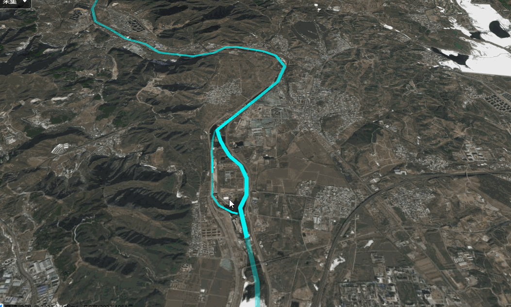
三、分析
主要运用高德地图PulseLineLayer实现,它连接飞线图层,可以支持弧度,宽度,过渡色等能力。 并且还支持脉冲动画,可以表达数据的朝向。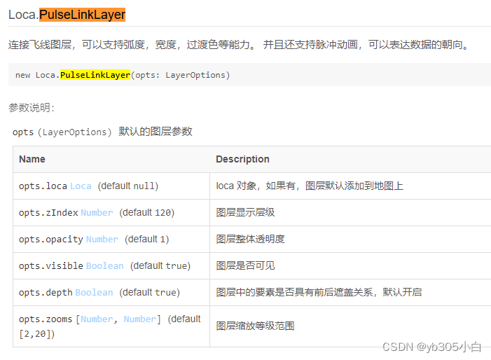
四、参考链接
高德地图实现脉冲线和飞线效果_高德地图飞线图_songywaa的博客-CSDN博客


![[Latex]newcommand\renewcommand\newtheorem的使用、总结、报错](https://img-blog.csdnimg.cn/0b02fcdaa74344ff81b9b44333d70357.png)