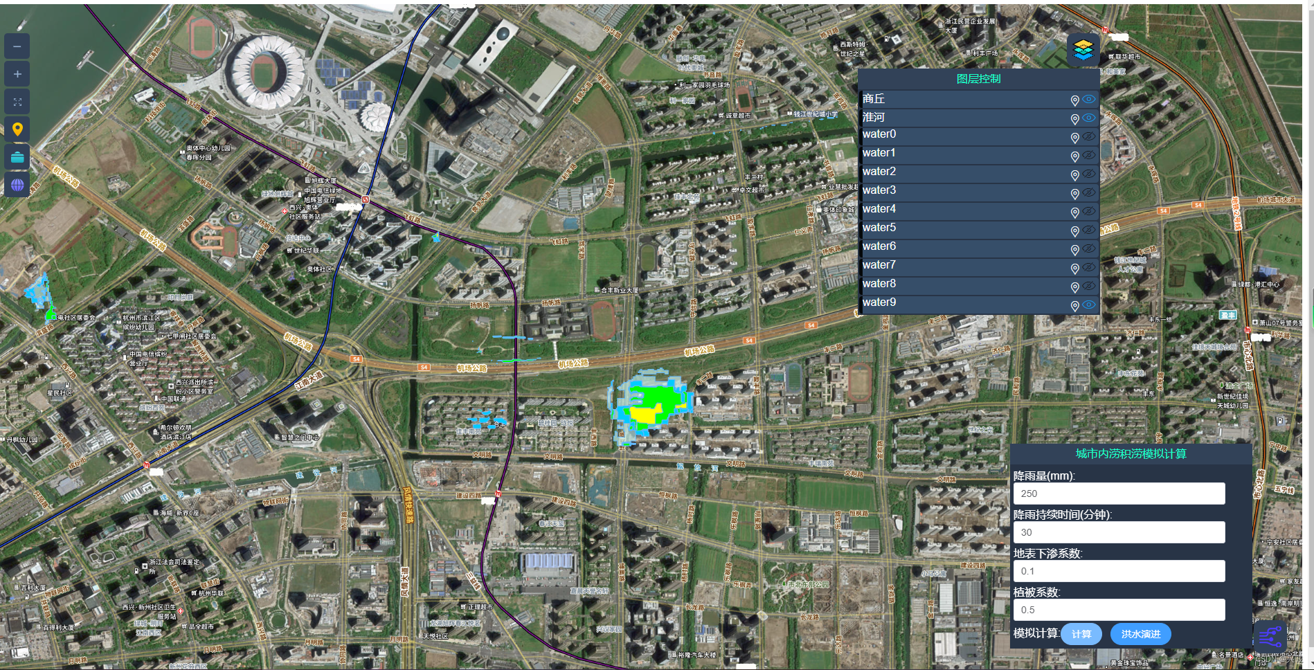
程序实现效果图
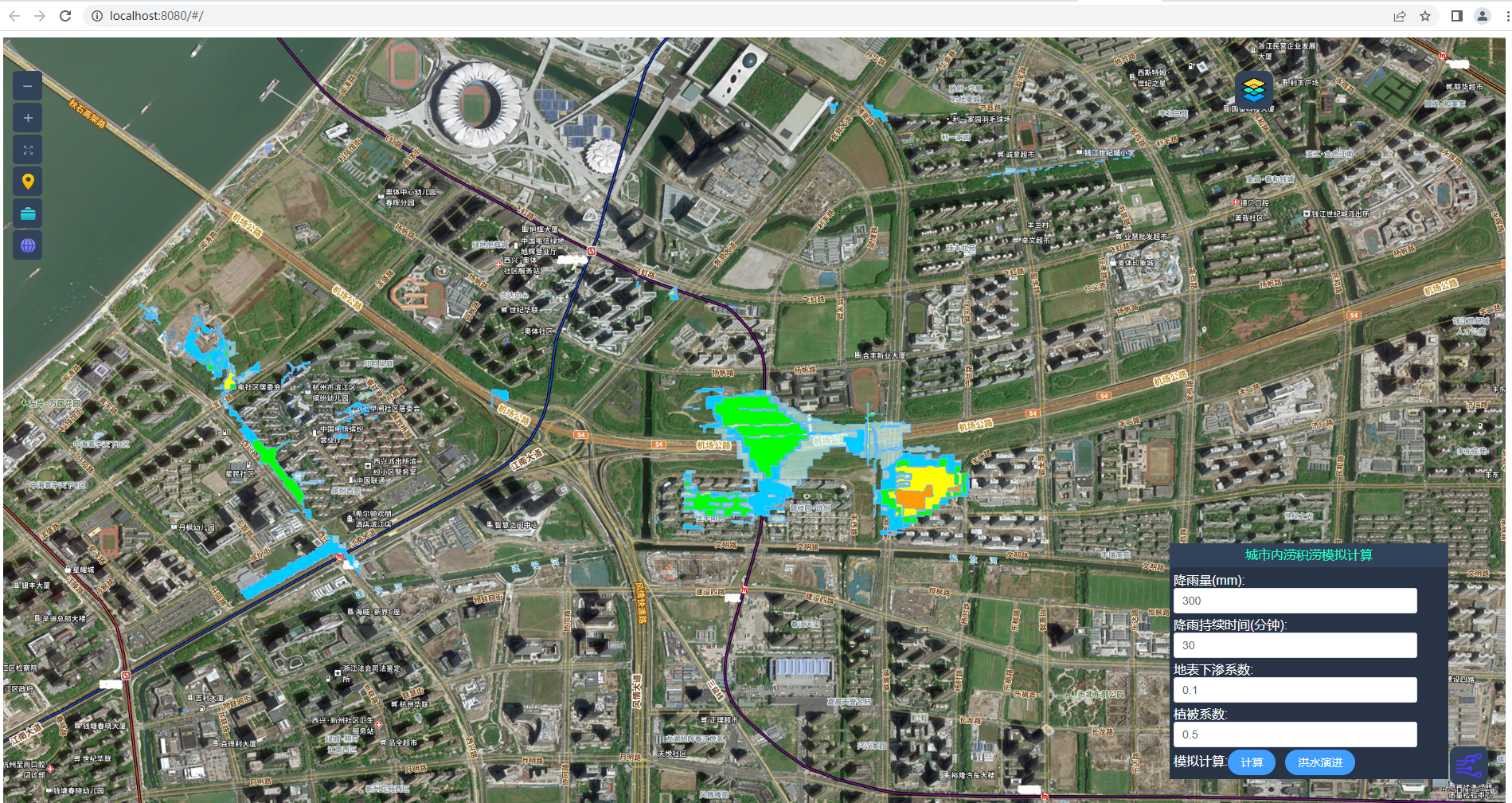
洪水演进过程


一、应用背景
城市内涝和积涝是一个严重的问题,特别是在气候变化的背景下。为了更好地了解这个问题,模拟城市内涝和积涝是非常重要的。这个过程可以帮助我们预测哪些区域可能会受到影响,以及在发生内涝和积涝时应该如何应对。同时,这个过程也可以帮助我们更好地规划城市建设,以减少内涝和积涝的发生。总的来说,城市内涝和积涝模拟是一个非常有价值的工具,可以帮助我们更好地应对这个问题,使城市更加安全和可持续。
城市内涝和积涝是一个全球性的问题,对城市的可持续发展和居民的生活质量都会产生影响。为了减少这些影响,我们需要采取措施来预测和应对内涝和积涝的发生。城市内涝和积涝模拟可以帮助我们更好地了解这个问题,以便我们在城市规划和应急响应方面做出更加科学和有效的决策。希望未来能够有更多的研究和投入来加强城市内涝和积涝模拟技术,让城市更加安全、可持续和宜居。
此外,还需要加强城市基础设施的建设,例如改善排水系统和城市绿地的规划。同时,也需要进行公众教育,提高居民的环保意识和应对内涝和积涝的能力。只有通过多方面的合作和努力,才能实现城市内涝和积涝的有效管理和缓解。让我们一起为创造更加美好的城市生活而努力。
除了进行城市内涝积涝模拟,我们还需要加强城市基础设施的建设。这包括改善排水系统和城市绿地的规划,以应对极端天气事件。与此同时,公众教育也很重要,我们需要提高居民的环保意识和应对内涝和积涝的能力。只有多方合作和努力,才能实现城市内涝和积涝的有效管理和缓解,让我们共同努力,创造更美好的城市生活。
二、常见城市内涝积涝场景


三、准备网格化的asc地形数据为模型计算提供基础数据(点位百万以上,如果卡顿,可分布式实现负载均衡解决)

四、关键java代码编写
/*
* Copyright 2021 zdh,
* zdh@gmail.com
*/
package wcontour;
import wcontour.KDTree.Euclidean;
import java.awt.geom.Point2D;
import java.util.ArrayList;
import java.util.List;
import static jdk.nashorn.internal.objects.Global.Infinity;
/**
* Interpolate class - including the functions of interpolation
*
* @author zdh
* @version $Revision: 1.6 $
*/
public class Interpolate {
// <editor-fold desc="IDW">
/**
* Create grid x/y coordinate arrays with x/y delt
*
* @param Xlb x of left-bottom
* @param Ylb y of left-bottom
* @param Xrt x of right-top
* @param Yrt y of right-top
* @param XDelt x delt
* @param YDelt y delt
* @return X/Y coordinate arrays
*/
public static List<double[]> createGridXY_Delt(double Xlb, double Ylb, double Xrt, double Yrt, double XDelt, double YDelt) {
int i, Xnum, Ynum;
Xnum = (int) ((Xrt - Xlb) / XDelt + 1);
Ynum = (int) ((Yrt - Ylb) / YDelt + 1);
double[] X = new double[Xnum];
double[] Y = new double[Ynum];
for (i = 0; i < Xnum; i++) {
X[i] = Xlb + i * XDelt;
}
for (i = 0; i < Ynum; i++) {
Y[i] = Ylb + i * YDelt;
}
List<double[]> values = new ArrayList<>();
values.add(X);
values.add(Y);
return values;
}
/**
* Create grid X/Y coordinate
*
* @param Xlb X left bottom 左下 x
* @param Ylb Y left bottom
* @param Xrt X right top 右上 x
* @param Yrt Y right top
* @param X X coordinate x 坐标
* @param Y Y coordinate y 坐标
*
* 根据x,y 的边界值,在边界值范围内生成一组 x[] 和 一组 y[]
*/
public static void createGridXY_Num(double Xlb, double Ylb, double Xrt, double Yrt,
double[] X, double[] Y) {
System.out.println("Interpolate.createGridXY_Num");
int i;
double XDelt, YDelt;
int Xnum = X.length;
int Ynum = Y.length;
XDelt = (Xrt - Xlb) / Xnum;
YDelt = (Yrt - Ylb) / Ynum;
for (i = 0; i < Xnum; i++) {
X[i] = Xlb + i * XDelt;
}
for (i = 0; i < Ynum; i++) {
Y[i] = Ylb + i * YDelt;
}
}
/**
* 用IDW邻接法插值
* Interpolation with IDW neighbor method
*
* @param SCoords discrete data array
* @param X grid X array
* @param Y grid Y array
* @param NumberOfNearestNeighbors number of nearest neighbors
* @return grid data
*/
public static double[][] interpolation_IDW_Neighbor(double[][] SCoords, double[] X, double[] Y,
int NumberOfNearestNeighbors) {
int rowNum, colNum, pNum;
colNum = X.length;
rowNum = Y.length;
pNum = SCoords.length;
double[][] GCoords = new double[rowNum][colNum];
int i, j, p, l, aP;
double w, SV, SW, aMin;
int points;
points = NumberOfNearestNeighbors;
Object[][] NW = new Object[2][points];
//---- Do interpolation
for (i = 0; i < rowNum; i++) {
for (j = 0; j < colNum; j++) {
GCoords[i][j] = -999.0;
SV = 0;
SW = 0;
for (p = 0; p < points; p++) {
if (X[j] == SCoords[p][0] && Y[i] == SCoords[p][1]) {
GCoords[i][j] = SCoords[p][2];
break;
} else {
w = 1 / (Math.pow(X[j] - SCoords[p][0], 2) + Math.pow(Y[i] - SCoords[p][1], 2));
NW[0][p] = w;
NW[1][p] = p;
}
}
if (GCoords[i][j] == -999.0) {
for (p = points; p < pNum; p++) {
if (Math.pow(X[j] - SCoords[p][0], 2) + Math.pow(Y[i] - SCoords[p][1], 2) == 0) {
GCoords[i][j] = SCoords[p][2];
break;
} else {
w = 1 / (Math.pow(X[j] - SCoords[p][0], 2) + Math.pow(Y[i] - SCoords[p][1], 2));
aMin = Double.parseDouble(NW[0][0].toString());
aP = 0;
for (l = 1; l < points; l++) {
if (Double.parseDouble(NW[0][l].toString()) < aMin) {
aMin = Double.parseDouble(NW[0][l].toString());
aP = l;
}
}
if (w > aMin) {
NW[0][aP] = w;
NW[1][aP] = p;
}
}
}
if (GCoords[i][j] == -999.0) {
for (p = 0; p < points; p++) {
SV += Double.parseDouble(NW[0][p].toString()) * SCoords[Integer.parseInt(NW[1][p].toString())][2];
SW += Double.parseDouble(NW[0][p].toString());
}
GCoords[i][j] = SV / SW;
}
}
}
}
//---- Smooth with 5 points
double s = 0.5;
for (i = 1; i < rowNum - 1; i++) {
for (j = 1; j < colNum - 1; j++) {
GCoords[i][j] = GCoords[i][j] + s / 4 * (GCoords[i + 1][j] + GCoords[i - 1][j]
+ GCoords[i][j + 1] + GCoords[i][j - 1] - 4 * GCoords[i][j]);
}
}
return GCoords;
}
/**
* 用IDW邻接法插值
* Interpolation with IDW neighbor method
*
* @param SCoords discrete data array
* @param X grid X array
* @param Y grid Y array
* @param NumberOfNearestNeighbors number of nearest neighbors
* @param unDefData undefine data
* @return interpolated grid data
*/
public static double[][] interpolation_IDW_Neighbor(double[][] SCoords, double[] X, double[] Y,
int NumberOfNearestNeighbors, double unDefData) {
int rowNum, colNum, pNum;
colNum = X.length;
rowNum = Y.length;
pNum = SCoords.length;
double[][] GCoords = new double[rowNum][colNum];
int i, j, p, l, aP;
double w, SV, SW, aMin;
int points;
points = NumberOfNearestNeighbors;
double[] AllWeights = new double[pNum];
double[][] NW = new double[2][points];
int NWIdx;
//---- Do interpolation with IDW method
for (i = 0; i < rowNum; i++) {
for (j = 0; j < colNum; j++) {
GCoords[i][j] = unDefData;
SV = 0;
SW = 0;
NWIdx = 0;
for (p = 0; p < pNum; p++) {
if (SCoords[p][2] == unDefData) {
AllWeights[p] = -1;
continue;
}
if (X[j] == SCoords[p][0] && Y[i] == SCoords[p][1]) {
GCoords[i][j] = SCoords[p][2];
break;
} else {
w = 1 / (Math.pow(X[j] - SCoords[p][0], 2) + Math.pow(Y[i] - SCoords[p][1], 2));
AllWeights[p] = w;
if (NWIdx < points) {
NW[0][NWIdx] = w;
NW[1][NWIdx] = p;
}
NWIdx += 1;
}
}
if (GCoords[i][j] == unDefData) {
for (p = 0; p < pNum; p++) {
w = AllWeights[p];
if (w == -1) {
continue;
}
aMin = NW[0][0];
aP = 0;
for (l = 1; l < points; l++) {
if ((double) NW[0][l] < aMin) {
aMin = (double) NW[0][l];
aP = l;
}
}
if (w > aMin) {
NW[0][aP] = w;
NW[1][aP] = p;
}
}
for (p = 0; p < points; p++) {
SV += (double) NW[0][p] * SCoords[(int) NW[1][p]][2];
SW += (double) NW[0][p];
}
GCoords[i][j] = SV / SW;
}
}
}
//---- Smooth with 5 points
double s = 0.5;
for (i = 1; i < rowNum - 1; i++) {
for (j = 1; j < colNum - 1; j++) {
GCoords[i][j] = GCoords[i][j] + s / 4 * (GCoords[i + 1][j] + GCoords[i - 1][j] + GCoords[i][j + 1]
+ GCoords[i][j - 1] - 4 * GCoords[i][j]);
}
}
return GCoords;
}
/**
* IDW半径法插值
*
* 反距离权重法
* Interpolation with IDW radius method
*
* @param SCoords discrete data array
* @param X grid X array
* @param Y grid Y array
* @param NeededPointNum needed at least point number
* @param radius search radius
* @param unDefData undefine data
* @return interpolated grid data 插值后的网格数据
*/
public static double[][] interpolation_IDW_Radius(double[][] SCoords, double[] X, double[] Y,
int NeededPointNum, double radius, double unDefData) {
System.out.println("Interpolate.interpolation_IDW_Radius");
int rowNum, colNum, pNum;
colNum = X.length;
rowNum = Y.length;
pNum = SCoords.length;
double[][] GCoords = new double[rowNum][colNum];
int i, j, p, vNum;
double w, SV, SW;
boolean ifPointGrid;
//---- Do interpolation
for (i = 0; i < rowNum; i++) {
for (j = 0; j < colNum; j++) {
GCoords[i][j] = unDefData;
ifPointGrid = false;
SV = 0;
SW = 0;
vNum = 0;
for (p = 0; p < pNum; p++) {
if (SCoords[p][2] == unDefData) {
continue;
}
if (SCoords[p][0] < X[j] - radius || SCoords[p][0] > X[j] + radius || SCoords[p][1] < Y[i] - radius
|| SCoords[p][1] > Y[i] + radius) {
continue;
}
if (X[j] == SCoords[p][0] && Y[i] == SCoords[p][1]) {
GCoords[i][j] = SCoords[p][2];
ifPointGrid = true;
break;
} else if (Math.sqrt(Math.pow(X[j] - SCoords[p][0], 2)
+ Math.pow(Y[i] - SCoords[p][1], 2)) <= radius) {
w = 1 / (Math.pow(X[j] - SCoords[p][0], 2) + Math.pow(Y[i] - SCoords[p][1], 2));
SW = SW + w;
SV = SV + SCoords[p][2] * w;
vNum += 1;
}
}
if (!ifPointGrid) {
if (vNum >= NeededPointNum) {
GCoords[i][j] = SV / SW;
}
}
}
}
//---- Smooth with 5 points
double s = 0.5;
for (i = 1; i < rowNum - 1; i++) {
for (j = 1; j < colNum - 2; j++) {
if (GCoords[i][j] == unDefData || GCoords[i + 1][j] == unDefData || GCoords[i - 1][j]
== unDefData || GCoords[i][j + 1] == unDefData || GCoords[i][j - 1] == unDefData) {
continue;
}
GCoords[i][j] = GCoords[i][j] + s / 4 * (GCoords[i + 1][j] + GCoords[i - 1][j] + GCoords[i][j + 1]
+ GCoords[i][j - 1] - 4 * GCoords[i][j]);
}
}
return GCoords;
}
/**
* Interpolation with IDW radius method - using KDTree for fast search
*
* @param stData discrete data array
* @param xGrid grid X array
* @param yGrid grid Y array
* @param neededPointNum needed at least point number
* @param radius search radius
* @param fillValue Fill value
* @return interpolated grid data
*/
public static double[][] idw_Radius_kdTree(double[][] stData, double[] xGrid, double[] yGrid,
int neededPointNum, double radius, double fillValue) {
Euclidean<double[]> kdtree = new Euclidean<>(2);
int l = stData.length;
for (int i = 0; i < l; i++) {
//Avoid key repeat
double nodex = stData[i][0] + (Math.random() * 10e-5);
double nodey = stData[i][1] + (Math.random() * 10e-5);
kdtree.addPoint(new double[]{nodex, nodey}, new double[]{stData[i][0], stData[i][1], stData[i][2]});
}
int w = xGrid.length;
int h = yGrid.length;
double[][] grid = new double[h][w];
for (int i = 0; i < h; i++) {
double yValue = yGrid[i];
for (int j = 0; j < w; j++) {
double xValue = xGrid[j];
List<double[]> nearPntList = kdtree.ballSearch(new double[]{xValue, yValue}, radius);
int nearSize = nearPntList.size();
if (nearSize < neededPointNum) {
grid[i][j] = fillValue;
continue;
}
double z_sum = 0.0;
double weight_sum = 0.0;
for (int k = 0; k < nearSize; k++) {
double[] xyz = nearPntList.get(k);
double distance = Point2D.Double.distance(xValue, yValue, xyz[0], xyz[1]);
if (distance <= radius && distance > 0) {
weight_sum += radius / distance;
z_sum += radius / distance * xyz[2];
} else if (Math.abs(distance) < 0.0001) { //Using point value when the grid is point
z_sum = xyz[2];
weight_sum = 1.0f;
break;
}
}
if (Math.abs(weight_sum) < 0.0001) {
grid[i][j] = fillValue;
} else {
grid[i][j] = z_sum / weight_sum;
}
}
}
return grid;
}
/**
* Interpolate from grid data
*
* @param GridData input grid data
* @param X input x coordinates
* @param Y input y coordinates
* @param unDefData undefine data
* @param nX output x coordinate
* @param nY output y coordinate
* @return output grid data
*/
public static double[][] interpolation_Grid(double[][] GridData, double[] X, double[] Y, double unDefData,
double[] nX, double[] nY) {
int nxNum = X.length * 2 - 1;
int nyNum = Y.length * 2 - 1;
nX = new double[nxNum];
nY = new double[nyNum];
double[][] nGridData = new double[nyNum][nxNum];
int i, j;
double a, b, c, d;
List<Double> dList;
for (i = 0; i < nxNum; i++) {
if (i % 2 == 0) {
nX[i] = X[i / 2];
} else {
nX[i] = (X[(i - 1) / 2] + X[(i - 1) / 2 + 1]) / 2;
}
}
for (i = 0; i < nyNum; i++) {
if (i % 2 == 0) {
nY[i] = Y[i / 2];
} else {
nY[i] = (Y[(i - 1) / 2] + Y[(i - 1) / 2 + 1]) / 2;
}
for (j = 0; j < nxNum; j++) {
if (i % 2 == 0 && j % 2 == 0) {
nGridData[i][j] = GridData[i / 2][j / 2];
} else if (i % 2 == 0 && j % 2 != 0) {
a = GridData[i / 2][(j - 1) / 2];
b = GridData[i / 2][(j - 1) / 2 + 1];
dList = new ArrayList<>();
if (a != unDefData) {
dList.add(a);
}
if (b != unDefData) {
dList.add(b);
}
if (dList.isEmpty()) {
nGridData[i][j] = unDefData;
} else if (dList.size() == 1) {
nGridData[i][j] = dList.get(0);
} else {
nGridData[i][j] = (a + b) / 2;
}
} else if (i % 2 != 0 && j % 2 == 0) {
a = GridData[(i - 1) / 2][j / 2];
b = GridData[(i - 1) / 2 + 1][j / 2];
dList = new ArrayList<>();
if (a != unDefData) {
dList.add(a);
}
if (b != unDefData) {
dList.add(b);
}
if (dList.isEmpty()) {
nGridData[i][j] = unDefData;
} else if (dList.size() == 1) {
nGridData[i][j] = dList.get(0);
} else {
nGridData[i][j] = (a + b) / 2;
}
} else {
a = GridData[(i - 1) / 2][(j - 1) / 2];
b = GridData[(i - 1) / 2][(j - 1) / 2 + 1];
c = GridData[(i - 1) / 2 + 1][(j - 1) / 2 + 1];
d = GridData[(i - 1) / 2 + 1][(j - 1) / 2];
dList = new ArrayList<>();
if (a != unDefData) {
dList.add(a);
}
if (b != unDefData) {
dList.add(b);
}
if (c != unDefData) {
dList.add(c);
}
if (d != unDefData) {
dList.add(d);
}
if (dList.isEmpty()) {
nGridData[i][j] = unDefData;
} else if (dList.size() == 1) {
nGridData[i][j] = dList.get(0);
} else {
double aSum = 0;
for (double dd : dList) {
aSum += dd;
}
nGridData[i][j] = aSum / dList.size();
}
}
}
}
return nGridData;
}
// </editor-fold>
// <editor-fold desc="Cressman">
/**
* Cressman analysis
*
* @param stationData station data array - x,y,value
* @param X x array
* @param Y y array
* @param unDefData undefine data
* @return grid data
*/
public static double[][] cressman(double[][] stationData, double[] X, double[] Y, double unDefData) {
List<Double> radList = new ArrayList<>();
radList.add(10.0);
radList.add(7.0);
radList.add(4.0);
radList.add(2.0);
radList.add(1.0);
return cressman(stationData, X, Y, unDefData, radList);
}
/**
* Cressman analysis
*
* @param stData station data array - x,y,value
* @param X x array
* @param Y y array
* @param unDefData undefine data
* @param radList radii list
* @return result grid data
*/
public static double[][] cressman(double[][] stData, double[] X, double[] Y, double unDefData, List<Double> radList) {
int xNum = X.length;
int yNum = Y.length;
int pNum = stData.length;
double[][] gridData = new double[yNum][xNum];
int irad = radList.size();
int i, j;
//Loop through each stn report and convert stn lat/lon to grid coordinates
double xMin = X[0];
double xMax = X[X.length - 1];
double yMin = Y[0];
double yMax = Y[Y.length - 1];
double xDelt = X[1] - X[0];
double yDelt = Y[1] - Y[0];
double x, y;
double sum = 0, total = 0;
int stNum = 0;
double[][] stationData = new double[pNum][3];
for (i = 0; i < pNum; i++) {
x = stData[i][0];
y = stData[i][1];
stationData[i][0] = (x - xMin) / xDelt;
stationData[i][1] = (y - yMin) / yDelt;
stationData[i][2] = stData[i][2];
if (stationData[i][2] != unDefData) {
total += stationData[i][2];
stNum += 1;
}
}
total = total / stNum;
//Initial the arrays
double HITOP = -999900000000000000000.0;
double HIBOT = 999900000000000000000.0;
double[][] TOP = new double[yNum][xNum];
double[][] BOT = new double[yNum][xNum];
for (i = 0; i < yNum; i++) {
for (j = 0; j < xNum; j++) {
TOP[i][j] = HITOP;
BOT[i][j] = HIBOT;
}
}
//Initial grid values are average of station reports within the first radius
Double rad;
if (radList.size() > 0) {
rad = radList.get(0);
} else {
rad = 4.0;
}
for (i = 0; i < yNum; i++) {
y = (double) i;
yMin = y - rad;
yMax = y + rad;
for (j = 0; j < xNum; j++) {
x = (double) j;
xMin = x - rad;
xMax = x + rad;
stNum = 0;
sum = 0;
for (int s = 0; s < pNum; s++) {
double val = stationData[s][2];
double sx = stationData[s][0];
double sy = stationData[s][1];
if (sx < 0 || sx >= xNum - 1 || sy < 0 || sy >= yNum - 1) {
continue;
}
if (val == unDefData || sx < xMin || sx > xMax || sy < yMin || sy > yMax) {
continue;
}
double dis = Math.sqrt(Math.pow(sx - x, 2) + Math.pow(sy - y, 2));
if (dis > rad) {
continue;
}
sum += val;
stNum += 1;
if (TOP[i][j] < val) {
TOP[i][j] = val;
}
if (BOT[i][j] > val) {
BOT[i][j] = val;
}
}
if (stNum == 0) {
gridData[i][j] = unDefData;
} else {
gridData[i][j] = sum / stNum;
}
}
}
//Perform the objective analysis
for (int p = 0; p < irad; p++) {
rad = radList.get(p);
for (i = 0; i < yNum; i++) {
y = (double) i;
yMin = y - rad;
yMax = y + rad;
for (j = 0; j < xNum; j++) {
if (gridData[i][j] == unDefData) {
continue;
}
x = (double) j;
xMin = x - rad;
xMax = x + rad;
sum = 0;
double wSum = 0;
for (int s = 0; s < pNum; s++) {
double val = stationData[s][2];
double sx = stationData[s][0];
double sy = stationData[s][1];
if (sx < 0 || sx >= xNum - 1 || sy < 0 || sy >= yNum - 1) {
continue;
}
if (val == unDefData || sx < xMin || sx > xMax || sy < yMin || sy > yMax) {
continue;
}
double dis = Math.sqrt(Math.pow(sx - x, 2) + Math.pow(sy - y, 2));
if (dis > rad) {
continue;
}
int i1 = (int) sy;
int j1 = (int) sx;
int i2 = i1 + 1;
int j2 = j1 + 1;
double a = gridData[i1][j1];
double b = gridData[i1][j2];
double c = gridData[i2][j1];
double d = gridData[i2][j2];
List<Double> dList = new ArrayList<>();
if (a != unDefData) {
dList.add(a);
}
if (b != unDefData) {
dList.add(b);
}
if (c != unDefData) {
dList.add(c);
}
if (d != unDefData) {
dList.add(d);
}
double calVal;
if (dList.isEmpty()) {
continue;
} else if (dList.size() == 1) {
calVal = dList.get(0);
} else if (dList.size() <= 3) {
double aSum = 0;
for (double dd : dList) {
aSum += dd;
}
calVal = aSum / dList.size();
} else {
double x1val = a + (c - a) * (sy - i1);
double x2val = b + (d - b) * (sy - i1);
calVal = x1val + (x2val - x1val) * (sx - j1);
}
double eVal = val - calVal;
double w = (rad * rad - dis * dis) / (rad * rad + dis * dis);
sum += eVal * w;
wSum += w;
}
if (wSum < 0.000001) {
gridData[i][j] = unDefData;
} else {
double aData = gridData[i][j] + sum / wSum;
gridData[i][j] = Math.max(BOT[i][j], Math.min(TOP[i][j], aData));
}
}
}
}
//Return
return gridData;
}
/**
* Cressman analysis - KDTree
*
* @param stationData station data array - x,y,value
* @param X x array
* @param Y y array
* @param unDefData undefine data
* @return grid data
*/
public static double[][] cressman_kdTree(double[][] stationData, double[] X, double[] Y, double unDefData) {
List<Double> radList = new ArrayList<>();
radList.add(10.0);
radList.add(7.0);
radList.add(4.0);
radList.add(2.0);
radList.add(1.0);
return cressman_kdTree(stationData, X, Y, unDefData, radList);
}
/**
* Cressman analysis - KDTree
*
* @param stData station data array - x,y,value
* @param X x array
* @param Y y array
* @param unDefData undefine data
* @param radList radii list
* @return result grid data
*/
public static double[][] cressman_kdTree(double[][] stData, double[] X, double[] Y, double unDefData, List<Double> radList) {
int xNum = X.length;
int yNum = Y.length;
int pNum = stData.length;
double[][] gridData = new double[yNum][xNum];
int irad = radList.size();
int i, j;
//Loop through each stn report and convert stn lat/lon to grid coordinates
double xMin = X[0];
double xMax = X[X.length - 1];
double yMin = Y[0];
double yMax = Y[Y.length - 1];
double xDelt = X[1] - X[0];
double yDelt = Y[1] - Y[0];
double x, y;
double sum = 0, total = 0;
int stNum = 0;
double[][] stationData = new double[pNum][3];
for (i = 0; i < pNum; i++) {
x = stData[i][0];
y = stData[i][1];
stationData[i][0] = (x - xMin) / xDelt;
stationData[i][1] = (y - yMin) / yDelt;
stationData[i][2] = stData[i][2];
if (stationData[i][2] != unDefData) {
total += stationData[i][2];
stNum += 1;
}
}
total = total / stNum;
Euclidean<double[]> kdTree = new Euclidean<>(2);
for(i = 0; i < pNum; i++){
kdTree.addPoint(new double[]{stationData[i][0], stationData[i][1]}, stationData[i]);
}
//Initial the arrays
double HITOP = -999900000000000000000.0;
double HIBOT = 999900000000000000000.0;
double[][] TOP = new double[yNum][xNum];
double[][] BOT = new double[yNum][xNum];
for (i = 0; i < yNum; i++) {
for (j = 0; j < xNum; j++) {
TOP[i][j] = HITOP;
BOT[i][j] = HIBOT;
}
}
//Initial grid values are average of station reports within the first radius
double rad;
if (radList.size() > 0) {
rad = radList.get(0);
} else {
rad = 4;
}
for (i = 0; i < yNum; i++) {
y = (double) i;
yMin = y - rad;
yMax = y + rad;
for (j = 0; j < xNum; j++) {
x = (double) j;
xMin = x - rad;
xMax = x + rad;
stNum = 0;
sum = 0;
ArrayList<double[]> neighbours = kdTree.ballSearch(new double[]{x,y}, rad*rad);
for (double[] station: neighbours) {
double val = station[2];
double sx = station[0];
double sy = station[1];
if (sx < 0 || sx >= xNum - 1 || sy < 0 || sy >= yNum - 1) {
continue;
}
if (val == unDefData || sx < xMin || sx > xMax || sy < yMin || sy > yMax) {
continue;
}
double dis = Math.sqrt(Math.pow(sx - x, 2) + Math.pow(sy - y, 2));
if (dis > rad) {
continue;
}
sum += val;
stNum += 1;
if (TOP[i][j] < val) {
TOP[i][j] = val;
}
if (BOT[i][j] > val) {
BOT[i][j] = val;
}
}
if (stNum == 0) {
gridData[i][j] = unDefData;
//gridData[i, j] = total;
} else {
gridData[i][j] = sum / stNum;
}
}
}
//Perform the objective analysis
for (int p = 0; p < irad; p++) {
rad = radList.get(p);
for (i = 0; i < yNum; i++) {
y = (double) i;
yMin = y - rad;
yMax = y + rad;
for (j = 0; j < xNum; j++) {
if (gridData[i][j] == unDefData) {
continue;
}
x = (double) j;
xMin = x - rad;
xMax = x + rad;
sum = 0;
double wSum = 0;
ArrayList<double[]> neighbours = kdTree.ballSearch(new double[]{x,y}, rad*rad);
for(double[] station: neighbours){
double val = station[2];
double sx = station[0];
double sy = station[1];
if (sx < 0 || sx >= xNum - 1 || sy < 0 || sy >= yNum - 1) {
continue;
}
if (val == unDefData || sx < xMin || sx > xMax || sy < yMin || sy > yMax) {
continue;
}
double dis = Math.sqrt(Math.pow(sx - x, 2) + Math.pow(sy - y, 2));
if (dis > rad) {
continue;
}
int i1 = (int) sy;
int j1 = (int) sx;
int i2 = i1 + 1;
int j2 = j1 + 1;
double a = gridData[i1][j1];
double b = gridData[i1][j2];
double c = gridData[i2][j1];
double d = gridData[i2][j2];
List<Double> dList = new ArrayList<>();
if (a != unDefData) {
dList.add(a);
}
if (b != unDefData) {
dList.add(b);
}
if (c != unDefData) {
dList.add(c);
}
if (d != unDefData) {
dList.add(d);
}
double calVal;
if (dList.isEmpty()) {
continue;
} else if (dList.size() == 1) {
calVal = dList.get(0);
} else if (dList.size() <= 3) {
double aSum = 0;
for (double dd : dList) {
aSum += dd;
}
calVal = aSum / dList.size();
} else {
double x1val = a + (c - a) * (sy - i1);
double x2val = b + (d - b) * (sy - i1);
calVal = x1val + (x2val - x1val) * (sx - j1);
}
double eVal = val - calVal;
double w = (rad * rad - dis * dis) / (rad * rad + dis * dis);
sum += eVal * w;
wSum += w;
}
if (wSum < 0.000001) {
gridData[i][j] = unDefData;
} else {
double aData = gridData[i][j] + sum / wSum;
gridData[i][j] = Math.max(BOT[i][j], Math.min(TOP[i][j], aData));
}
}
}
}
//Return
return gridData;
}
// </editor-fold>
// <editor-fold desc="Others">
/**
* Assign point value to grid value
*
* @param SCoords point value array
* @param X x coordinate
* @param Y y coordinate
* @param unDefData undefine value
* @return grid data
*/
public static double[][] assignPointToGrid(double[][] SCoords, double[] X, double[] Y,
double unDefData) {
int rowNum, colNum, pNum;
colNum = X.length;
rowNum = Y.length;
pNum = SCoords.length;
double[][] GCoords = new double[rowNum][colNum];
double dX = X[1] - X[0];
double dY = Y[1] - Y[0];
int[][] pNums = new int[rowNum][colNum];
for (int i = 0; i < rowNum; i++) {
for (int j = 0; j < colNum; j++) {
pNums[i][j] = 0;
GCoords[i][j] = 0.0;
}
}
for (int p = 0; p < pNum; p++) {
if (doubleEquals(SCoords[p][2], unDefData)) {
continue;
}
double x = SCoords[p][0];
double y = SCoords[p][1];
if (x < X[0] || x > X[colNum - 1]) {
continue;
}
if (y < Y[0] || y > Y[rowNum - 1]) {
continue;
}
int j = (int) ((x - X[0]) / dX);
int i = (int) ((y - Y[0]) / dY);
pNums[i][j] += 1;
GCoords[i][j] += SCoords[p][2];
}
for (int i = 0; i < rowNum; i++) {
for (int j = 0; j < colNum; j++) {
if (pNums[i][j] == 0) {
GCoords[i][j] = unDefData;
} else {
GCoords[i][j] = GCoords[i][j] / pNums[i][j];
}
}
}
return GCoords;
}
private static boolean doubleEquals(double a, double b) {
//if (Math.Abs(a - b) < 0.000001)
if (Math.abs(a / b - 1) < 0.00000000001) {
return true;
} else {
return false;
}
}
// </editor-fold>
}
//getAscGeoJsonByCIdxSim
//http://localhost:8145/api/getAscGeoJsonByCIdxSim?rowInterval=868&rowIntervalIdxNum=0&crowIntervalIdx=0&rainVal=300&SurfaceInfiltration=0.6&vegetation=0.5
/**
* 索引从0开始
* @param rowInterval
* @param rowIntervalIdxNum
* @param crowIntervalIdx
* @return
*/
@GetMapping("/getAscGeoJsonByCIdxSim")
public String getAscGeoJsonByCIdxSim(int rowInterval,int rowIntervalIdxNum,int crowIntervalIdx,double rainVal,double SurfaceInfiltration,double vegetation) {
String ascGeoJson = ascGeo.getAscGeoJsonByCIdxSim(rowInterval,rowIntervalIdxNum,crowIntervalIdx,rainVal,SurfaceInfiltration,vegetation);
return ascGeoJson;
}
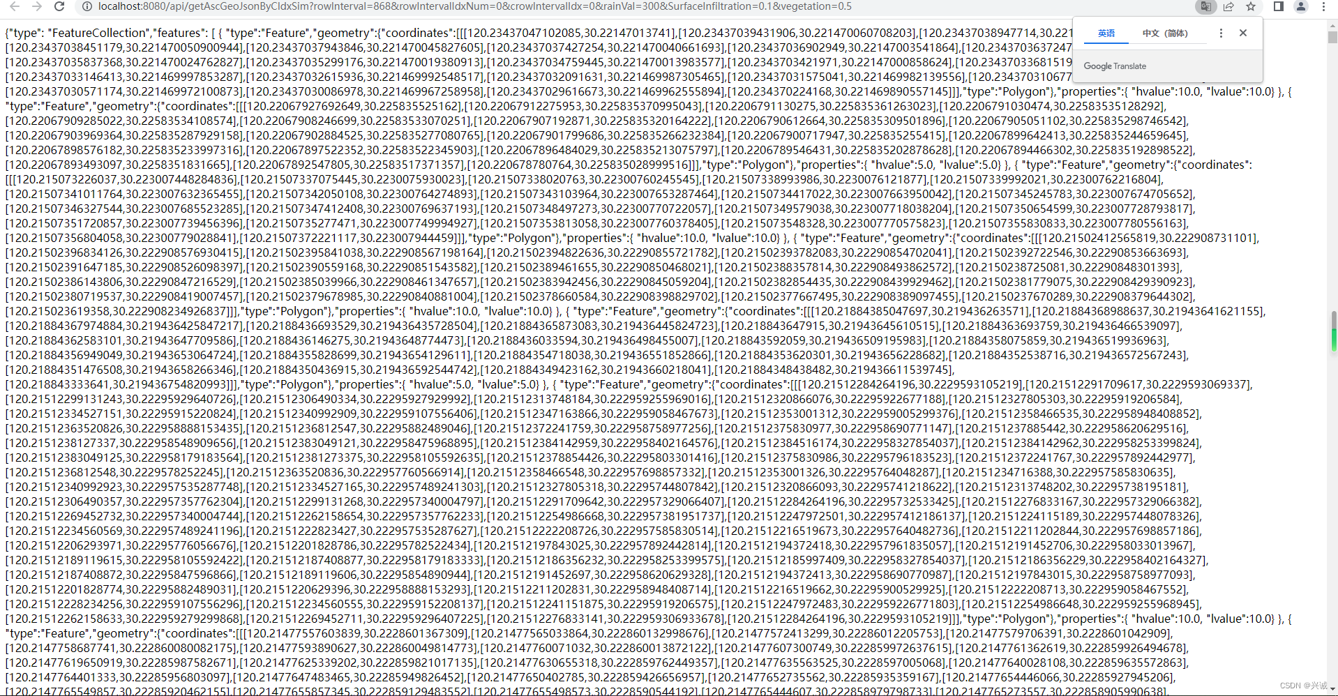
五、模型调用生成的结果数据为geojson
六、前端配置接入模型生成的成果geojson实现模拟洪水演进关键代码
<template>
  <div class="layerPanel">
    <div v-if="isPanelShow" class="layerPanel-content">
      <el-container>
        <el-header style="height: 30px">城市内涝积涝模拟计算</el-header>
        <el-main>
          <div>
            <div style="margin: 3px">
              <span>降雨量(mm):</span>
              <el-input v-model= 'RainVal' style="width: 90%;" clearable></el-input>
            </div>
            <div style="margin: 3px">
              <span>降雨持续时间(分钟):</span>
              <el-input v-model= 'IntervalTime' style="width: 90%;" clearable></el-input>
            </div>
            <div style="margin: 3px">
              <span>地表下渗系数:</span>
              <el-input v-model= 'SurfaceInfiltration' style="width: 90%;" clearable></el-input>
            </div>
            <div style="margin: 3px">
              <span>植被系数:</span>
              <el-input v-model= 'vegetation' style="width: 90%;" clearable></el-input>
            </div>
            <div style="margin: 3px">
              <span>模拟计算:</span>
              <el-button type="primary" round @click="simulationCalculate">计算</el-button>
              <el-button type="primary" round @click="FloodProgress">洪水演进</el-button>
            </div>
          </div>
        </el-main>
      </el-container>
    </div>
    <div class="layer-collapse" @click="layersPanelCollapse">
      <i class="layerlist"></i>
    </div>
  </div>
</template>

<script>
export default {
  data () {
    return {
      layers: 11,
      isPanelShow: false,
      clayersInfo: [],
      opacityValue: 100,
      RainVal: 300,
      IntervalTime: 30,
      SurfaceInfiltration: 0.1,
      vegetation: 0.5,
      count:0
    }
  },
  mounted () {

  },
  methods: {
    layersPanelCollapse () {
      this.isPanelShow = !this.isPanelShow
    },
    simulationCalculate(){
      this.$emit("WaterDiffSimulation", this.RainVal,this.IntervalTime,this.SurfaceInfiltration,this.vegetation)
    },
    FloodProgress () {
      let _this = this;
      if(this.count==10){
        this.count=0
        this.$emit("FloodProgress",9)
        return
      }else {
        setTimeout(function () {
          _this.FloodProgress()
        },1000)
      }
      this.$emit("FloodProgress",this.count)
      this.count+=1
    }
  },
  props: {
    startLonLat: Object
  }
}
</script>

<style lang="less" scoped>
@import "./assets/css/index";
</style>
七、模拟展示效果(可调整降雨量、下渗系数等参数,后续版本升级加入更多参数调校率定,技术合作交流qq:2401315930)


如果对您有所帮助,请打赏点赞支持!