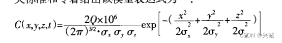
一、扩散公式整理
二、编写java代码实现
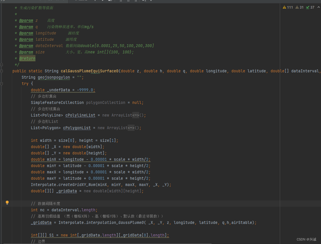
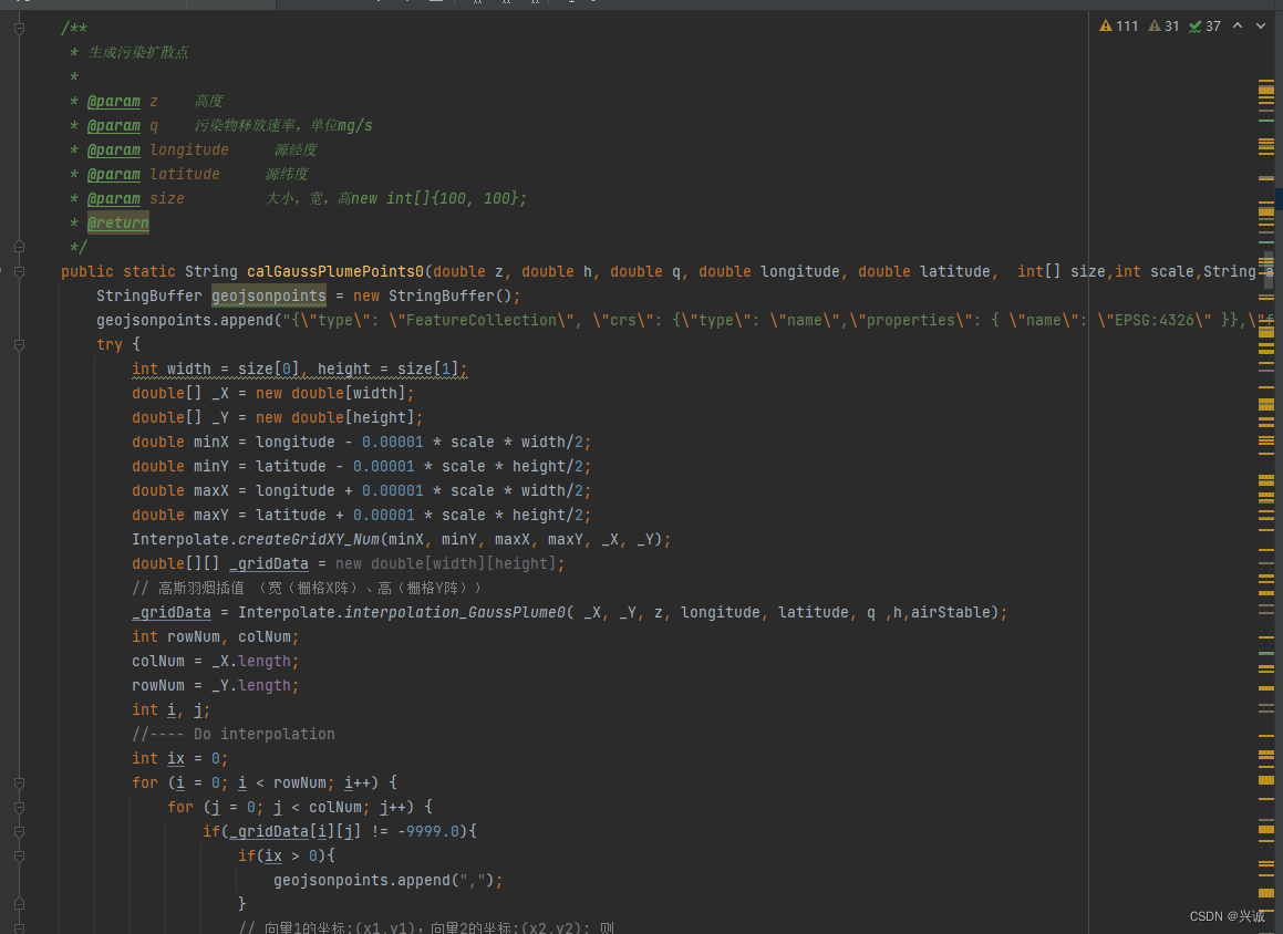
String strJson = InterpolationUtils.calGaussPlumePoints0(z,height,q,lon,lat, size,scale,airStable);
return strJson.replaceAll("NaN","0").replaceAll("Infinity",String.valueOf(q));
String strJson = InterpolationUtils.calGaussPlumeEquiSurface(z,height,u ,q,wd,lon,lat, dataInterval,size,scale,airStable);
return strJson;
三、前端openlayers调用代码
geoJsonFe:{
  renderType:"level",
  renderField:"hvalue",
  FieldScope:[{min:-1,max:29.9,symbol:Layersymbols.screenVecSymbol1},{min:29.9,max:49.9,symbol:Layersymbols.screenVecSymbol2},{min:49.9,max:69.9,symbol:Layersymbols.screenVecSymbol3},{min:69.9,max:89.0,symbol:Layersymbols.screenVecSymbol4},{min:89.9,max:149.9,symbol:Layersymbols.screenVecSymbol5},{min:149.9,max:999999,symbol:Layersymbols.screenVecSymbol6}]
},
geoJsonFeP:{
  renderType:"level",
  renderField:"val",
  FieldScope:[{min:-1,max:30,symbol:Layersymbols.aqiSymbol1},{min:30,max:50,symbol:Layersymbols.aqiSymbol2},{min:50,max:70,symbol:Layersymbols.aqiSymbol3},{min:70,max:90,symbol:Layersymbols.aqiSymbol4},{min:90,max:150,symbol:Layersymbols.aqiSymbol5},{min:150,max:999999,symbol:Layersymbols.aqiSymbol6}]
}
screenVecSymbol1:new Style({
  stroke: new Stroke({
    color: 'rgba(0, 206, 0, 0.1)',
    width: 1,
  }),
  fill: new Fill({
    color: 'rgba(0, 206, 0, 0.6)',
  }),
}),
screenVecSymbol2:new Style({
  stroke: new Stroke({
    color: 'rgba(254, 255, 3, 0.1)',
    width: 1,
  }),
  fill: new Fill({
    color: 'rgba(254, 255, 3, 0.6)',
  }),
}),
screenVecSymbol3:new Style({
  stroke: new Stroke({
    color: 'rgba(255, 101, 0, 0.1)',
    width: 1,
  }),
  fill: new Fill({
    color: 'rgba(255, 101, 0, 0.6)',
  }),
}),
screenVecSymbol4:new Style({
  stroke: new Stroke({
    color: 'rgba(254, 0, 0, 0.1)',
    width: 1,
  }),
  fill: new Fill({
    color: 'rgba(254, 0, 0, 0.6)',
  }),
}),
screenVecSymbol5:new Style({
  stroke: new Stroke({
    color: 'rgba(129, 0, 127, 0.1)',
    width: 1,
  }),
  fill: new Fill({
    color: 'rgba(129, 0, 127, 0.6)',
  }),
}),
screenVecSymbol6:new Style({
  stroke: new Stroke({
    color: 'rgba(128, 0, 0, 0.1)',
    width: 1,
  }),
  fill: new Fill({
    color: 'rgba(128, 0, 0, 0.6)',
  }),
}),
aqiSymbol1: new Style({
  image: new Circle({
    radius: 6,
    stroke: new Stroke({
      color: '#62B8FF',
    }),
    fill: new Fill({
      color: 'rgba(0, 206, 0, 1)'
    })
  })
}),
aqiSymbol2: new Style({
  image: new Circle({
    radius: 6,
    stroke: new Stroke({
      color: '#62B8FF',
    }),
    fill: new Fill({
      color: 'rgba(254, 255, 3, 1)'
    })
  })
}),
aqiSymbol3: new Style({
  image: new Circle({
    radius: 6,
    stroke: new Stroke({
      color: '#62B8FF',
    }),
    fill: new Fill({
      color: 'rgba(255, 101, 0, 1)'
    })
  })
}),
aqiSymbol4: new Style({
  image: new Circle({
    radius: 6,
    stroke: new Stroke({
      color: '#62B8FF',
    }),
    fill: new Fill({
      color: 'rgba(254, 0, 0, 1)'
    })
  })
}),
aqiSymbol5: new Style({
  image: new Circle({
    radius: 6,
    stroke: new Stroke({
      color: '#62B8FF',
    }),
    fill: new Fill({
      color: 'rgba(129, 0, 127, 1)'
    })
  })
}),
aqiSymbol6: new Style({
  image: new Circle({
    radius: 6,
    stroke: new Stroke({
      color: '#62B8FF',
    }),
    fill: new Fill({
      color: 'rgba(128, 0, 0, 1)'
    })
  })
})
//通用创建geojson要素
export function commonCreateGeojsonFeatures (map, layerKey, LayersRenderSet, geo, labelField) {
  if (Object.keys(geo).length == 0 && geo.features.length == 0) return;
  let features = geo.features;
  for (let i in features) {
    let areaFeature = {};

    if (features[i].geometry.type == "MultiPolygon") {
      areaFeature = new Feature({
        geometry: new MultiPolygon(features[i].geometry.coordinates),
      });
    } else if (features[i].geometry.type == "Polygon") {
      areaFeature = new Feature({
        geometry: new Polygon(features[i].geometry.coordinates),
      });
    }
    else if (features[i].geometry.type == "MultiLineString") {
      areaFeature = new Feature({
        geometry: new MultiLineString(features[i].geometry.coordinates),
      });
    }
    else if (features[i].geometry.type == "LineString") {
      areaFeature = new Feature({
        geometry: new LineString(features[i].geometry.coordinates),
      });
    }
    else if (features[i].geometry.type == "Point") {
      areaFeature = new Feature({
        geometry: new Point(features[i].geometry.coordinates),
      });
    }
    let featureStyle = getLyaerRenderSymbol(LayersRenderSet, layerKey, features[i].properties).clone()
    areaFeature.setStyle(featureStyle)
    areaFeature.setProperties(features[i].properties);
    areaFeature.values_.values_=features[i].properties
    getLayerByCode(map,layerKey).getSource().addFeature(areaFeature);
    if (features[i].properties[labelField] != undefined && labelField != '') {
      setFeatureLabel(areaFeature,features[i].properties[labelField].toString())
    }
  }
}
四、模拟效果展示
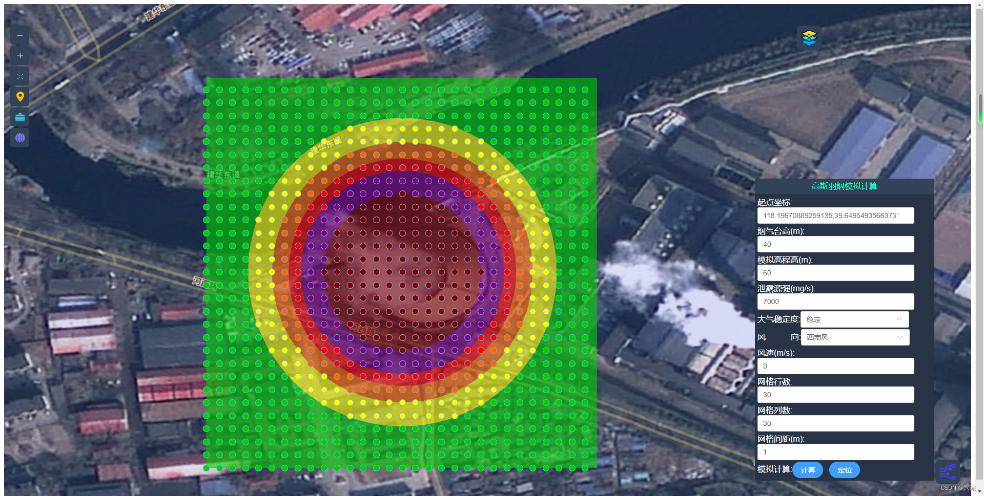
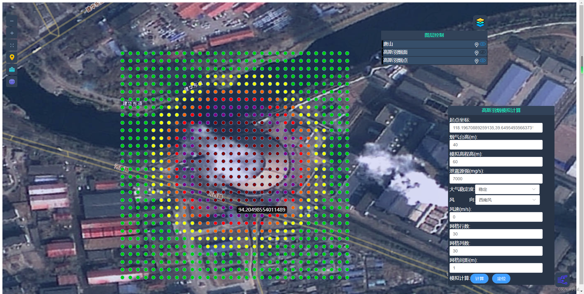
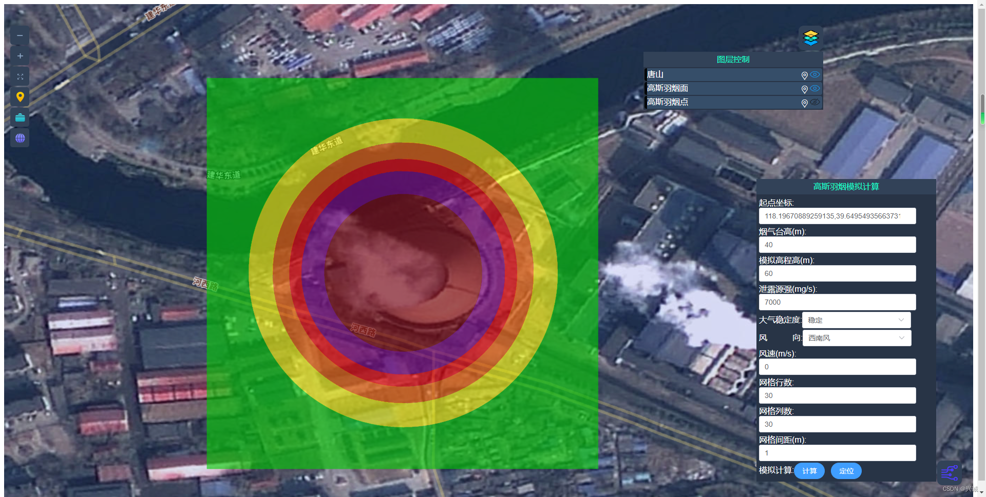
有风模拟参照:高斯羽烟gis应用java实现模型计算_兴诚的博客-CSDN博客
如果对您有所帮助请点赞打赏支持!
技术合作交流qq:2401315930


![【PWN刷题__ret2text】[BJDCTF 2020]babystack](https://img-blog.csdnimg.cn/1ab107b013584c0c973b5251a57fb9f0.png)